AI maps Dún Laoghaire-Rathdown’s street trees in detail
Dún Laoghaire-Rathdown has launched Ireland’s first AI-powered tree survey, mapping 20,000 street trees to strengthen urban biodiversity and climate resilience. The digital twin project will guide smarter planting and maintenance across the county.
•
⏱️ 2 min read
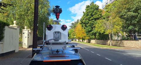
Dún Laoghaire-Rathdown County Council has pioneered a groundbreaking pilot programme this September, becoming the first local authority in Ireland to deploy artificial intelligence and LiDAR technology for a comprehensive street tree survey. The initiative will map and analyse approximately 20,000 trees across the county, with 10,000 trees assessed on each side, using advanced data collection techniques designed to revolutionise urban forest management.
The survey utilises AI and LiDAR to create detailed digital twins of each tree, capturing over 70 data points on health, structural integrity and environmental context. This wealth of information will inform smarter planting strategies, targeted maintenance programmes and climate resilience efforts, ensuring the long-term sustainability of the county’s green infrastructure. Trees play a crucial role in improving air quality, storing carbon, reducing urban heat and supporting local wildlife.
The findings will guide future investment in tree planting and canopy expansion, directly supporting the Council’s biodiversity and climate action objectives. Cllr Barry Saul, Cathaoirleach of Dún Laoghaire-Rathdown County Council, highlighted the project’s significance, stating that the data will help preserve the county’s natural assets for generations. Chief Executive Frank Curran emphasised dlr’s commitment to innovation, noting that the initiative sets a new standard for sustainable urban forestry in Ireland.
0 views